When you click on links to various merchants on this site and make a purchase, this can result in this site earning a commission. Affiliate programs and affiliations include, but are not limited to, the eBay Partner Network.
Comes with hand-signed C.O.A.
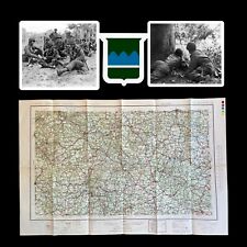
This original, exceptionally rare and museum-grade TOP SECRET D-Day (Utah Beach) amphibious beachhead chart vividly illustrates the intensive planning and operational accuracy that was behind Operation Neptune, the largest amphibious seaborne invasion in history. Titled “UTAH AREA - BEACH CHARTLET” this particular amphibious chart was created under the direction of Vice-Admiral Sir John Edgell. Edgell oversaw all of the mapping projects related to World War II, and paid special attention to the TOP SECRET maps/charts his office prepared for Operation Neptune and Overlord (the larger Allied mission to re-take France). This chart was produced in February 1944, shortly after the TOP SECRET undercover surveys of the Normandy had been completed in January 1944.
This very rare Utah Beach invasion chart was used for both the planning and carried out U.S. amphibious operation on D-Day (June 6th, 1944). This heavily used combat fathom map was used for the direct navigation onto the D-Day Utah Beachhead by the American LCVP (Landing Craft Vehicle & Personal Higgins), LCI (Landing Craft Infantry), LCM (Landing Craft Medium), and LST (Landing Ship Tank).
There was an extremely limited print count on this “UTAH AREA - BEACH CHARTLET” as it even has an area for a USN ship compass to be placed for even more accurate navigation to the beach.
This map shows the ENTIRE Utah Beach area and includes all of the specified designated landing area from Saint-Martin-de-Varreville to Audouville-la-Hubert including: TARE GREEN, UNCLE RED, & VICTOR.
What makes this map so unique is that it shows very evident use and a ‘salty’ appearance. This map has zero fold lines which is very uncommon and rare. Other than showing very clear use, this map is in great condition given its age and the intensive battle/invasion it was used in.
D-Day and Utah Beach:
Airborne landings begin 0015
H-Hour, beach landings 0630
Lead Allied assault forces:
Airborne landings: 82nd & 101st US Airborne Divisions
Beach landings: 4th US Infantry Division
German defenders:
Troops from 709th Infantry Division, 91st Airlanding Division and 6th Parachute Regiment
Objectives:
Only four causeways lead away from the beach through an area that has been flooded by the German defenders. The US Airborne forces land early in the morning to take control of the inland ends of these causeways, as well as other key roads and bridges. They then have to hold these objectives until troops from the beach landings can reach them.
Hourly Timeline of D-Day Landing on Utah Beach:
0015
The first airborne pathfinders (101st US Airborne Division) land by parachute and quickly set up beacons to guide in the main body of airborne troops.
0019
The main body of 101st US Airborne Division begins landing by parachute and glider several miles behind the beaches. Many of the airborne troops are widely scattered and will take hours to re-group. Some paratroopers drop into flooded areas and drown.
0200
The main force of 82nd US Airborne Division begins landing. Some land in and around the town of Sainte Mère Église, a key objective.
0335
Heavy bombers of RAF Bomber Command attack German coastal gun batteries near Utah Beach. Their aim is to disable these batteries so they cannot fire on US troops who will land on the beaches in a few hours' time.
0405
Landing ships miles offshore begin lowering the landing craft that will take the assault infantry to the beach. Many troops have to climb down cargo nets from the ships into the landing craft.
0435
First waves of landing craft head for the beach.
0536
Allied warships begin firing their guns against the German defences. There are exchanges of fire between several warships and German coastal guns.
0600
Support landing craft begin firing guns and rockets against German defences along the beach.
0630
The first US troops (8th Regimental Combat Team) come ashore on schedule, but land at least 1,500 yards to the south of the intended sector. Fortunately this area is more lightly defended than their original objective. Shortly afterwards, most DD (swimming) tanks land successfully, though later than originally planned.
0800
Brigadier General Theodore Roosevelt orders in follow-up troops. He decides to continue at the new landing site rather than reverting to the original one. US engineers are clearing beach obstacles so that follow-up landing craft can get to the beach in more safety.
0900 – 1000
US troops begin moving off the beach, along two of the four causeways. Meanwhile further inland, German forces fiercely counter-attack the positions held by US airborne troops.
1100 – 1200
As US troops advance further inland there is still some German resistance and artillery fire. Some Americans wade through flooded areas in order to reach their objectives. US troops advancing off the beach link-up with 101st US Airborne Division.
2100 – 2300
The final US airborne troops arrive by glider to reinforce 82nd Airborne Division.
2400
Utah Beach: At the end of D-Day:After being scattered during their landings, only 2,500 out of 6,600 US airborne troops have so far regrouped. Troops who landed on the beach have reached 101st US Airborne Division, but have not yet fully linked up with 82nd US Airborne Division who landed further to the west.
2400
Casualties at Utah Beach on D-Day:Total casualty figures for D-Day were not recorded at the time and are difficult to confirm in full. In the airborne landings 2,499 men became casualties, including 238 killed. Of the troops landing on the beaches, 589 were casualties including 197 who died. At Utah Beach there were also 235 naval and 340 air forces casualties. German losses here are unknown.
Forces involved:
There are two sectors on Utah: Uncle Red and Tare Green, located between the towns of Les Dunes-de-Varreville (North) and La Madeleine (South). These beaches are defended by the 709th german infantry division which has installed seven strongpoints. Two coastal artillery batteries, located at Montebourg and Saint-Marcouf, can open fire on this beach, since these guns have a firing range of almost 30 kilometers. The 7th U.S. Army of Major General J. Lawton Collins will be engaged first. It is composed of the 8th, 22nd and 12nd infantry regiments of the 4th american infantry division led by Major General Raymond O. Barton. These units will launch the attack of Utah Beach on D-Day in order to capture the landing beach sectors, then to establish a solid beachhead and to carry out the junction with the airborne troops of the 82nd and 101st American airborne divisions.
The assault must take place early in the morning at 6.30, a timetable that corresponds to the lowest tide. The Allies voluntarily choose this moment because the defenses of beaches installed by the Germans are clearly visible at low tide. Thus, the engineers can clear breaches on the beach in order to disembark the reinforcements.
The assault:
Tuesday June 6, at 3 o’clock in the morning, the U fleet (Utah) arrives near the Cotentin beaches and damps at approximately 18 kilometers off the coast, a distance which limits the effectiveness of the German coastal batteries. The sunrise comes at 05:58 a.m. exactly, 28 minutes after the beginning of the bombardment of the German positions by the allied warships. This huge bombardment follows air raids carried out by thousand of allied bombers.
American soldiers of the 1st and 2nd Battalions (8th Infantry Regiment, 4th Infantry Division) who have embarked into the landing crafts are witnessing these bombardments which plow the French soil and fill the sky with immense plumes of smoke. Even though many of them suffer from a terrible seasickness, they are relieved to see their objectives under such a rain of steel. Two squadrons of amphibious “duplex drive” tanks are launched three kilometers from the shore and have to reach the beach areas by their own means thanks to two propellers and a rubber skirt. They progress in two waves of assault: the first one is composed of twelve “duplex drive” tanks and the second one is composed of sixteen identical tanks).
But the amphibious tanks are falling behind and are soon overtaken by the landing craft of the 2nd Battalion which take the lead of the offensive on the beach area nicknamed “Uncle Red”.
The 2nd Battalion lands on “Uncle Red” sector south-east of Saint-Martin-de-Varreville. The 1st Battalion lands fifteen minutes later on “Tare Green” beach area, east of Saint-Martin-de-Varreville, simultaneously with the amphibious tanks belonging to the 70th Tank Battalion (squadrons A and B). The latter reach the beach and immediately engage the opposing positions.
During the first minutes of the 4th Infantry Division’s landing on Utah Beach, the German shots are numerous but not very precise. Gradually, German machine guns leave room for random but deadly explosions of shells fired by field guns belonging to the German709. Infantry Division.
These guns open fire from positions a few kilometers west of the landing beach (notably near Brécourt manor) and are camouflaged so that the Allied aircraft patrolling the Norman sky do not spot them.
Very quickly, the beach is under control. The tide is low and discovers the beach defenses over a distance of nearly 300 meters between the dunes and the sea. The fifth assault wavelands half an hour after H Hour. At 7:30 am, engineers open gaps through the beach obstacles allowing the landing crafts to approach without a hitch.